July 8, 2020 Storms
Nebraska
It was a tough day for me, despite the fact that we stayed busy chasing a very active bunch of storms in Nebraska. There were nice, dramatic shelf clouds to behold. We watched storms from initiation until sunset. Based on that alone, it should have been a very satisfying day. But, we had a choice between two targets, and I'm never satisfied with what I've seen if I have to choose one of them. This was supposed to be the culmination of several days of chasing, following the trough eastward into Minnesota. As so often happens, the forecast became a bit more complex as the week progressed, and the target did not look simply to be only in Minnesota. There was a larger overall severe thunderstorm risk in Nebraska, and for the most part, that verified. The problem was that I had to commit to one target (central Minnesota) or the other (Nebraska). As far as the Minnesota risk was concerned, the forecast showed slightly weaker mid level flow mostly parallel to a cold front, and there were going to be thunderstorms over the area in the morning, which had the potential of undercutting the best mid-level flow with thunderstorm outflow and preventing full airmass recovery late in the day. Thus, the northward retreat of the outflow boundary and increase in low-level moisture appeared to a little uncertain, and we didn't know how strong the storms would become.
Also, the forecasts earlier in the week suggested Thursday (Day 2) would be a down day with weak or no thunderstorms in the high plain. However, that now looked different, with models forecasting a better moisture return into Colorado and Wyoming than before. That added motivation to choose the Nebraska target. The Minnesota target had a better chance of producing tornadoes given sufficient airmass recovery, but that recovery was in doubt. Nebraska had a certainty of interesting storms (maybe not tornadoes but probably a couple), and we could also save a lot of driving and get to Day 2 storms-- maybe some high plains magic.
It was actually not an easy decision at all, and we had to commit to one target or the other in the early morning before the extent of the recovery in Minnesota would become clear. The storms were over central and even into southern Minnesota as forecast, and the outflow boundary was pretty far south in the state. I made the decision to play it safe for a greater certainty of severe storms in Nebraska.
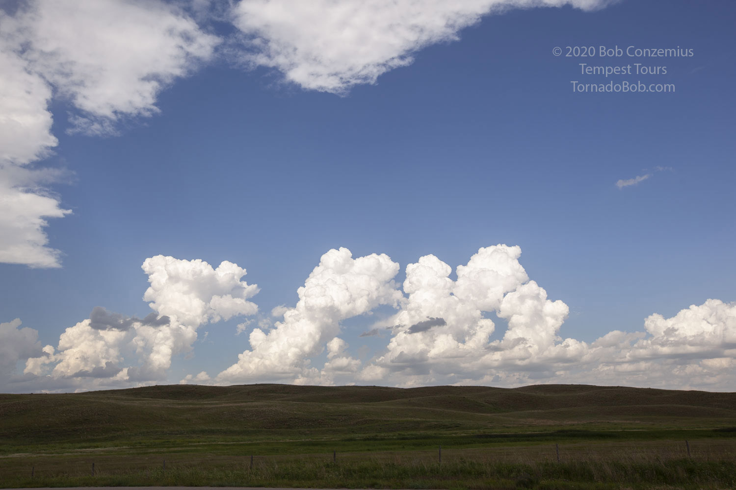
About 1:00 PM, when we were just entering Nebraska, I wished I had made the other decision. The storms were clearing out at least as quickly as forecast (often they persist longer than forecast, reinforcing the low-level cold air), and the skies were clear up into central Minnesota. Dewpoints appeared poised to reach into the low 70s by late in the day, and the wind was nice and southerly throughout the southern half of the state. There was no chance to get back to that target now, and the best thing to do would be to stick to the original plan. A dryline was forming over central Nebraska, and there appeared to be enough cyclonic vorticity along the boundary to produce a risk of tornadoes. We drove south to Hyannis, and then, noting the more robust cumulus just to our east, moved to Thedford and drove a few miles north. It was there where I checked the weather in Minnesota to find a mesoscale discussion. A watch would be issued soon with storms initiating along the Minnesota/North Dakota border and moving east. Soon, a small cell developed in Otter Tail County. It appeared to struggle a bit, so I was starting to feel hopeful that we were not missing a show in Minnesota. To our west, the dryline towers were developing into small storms, and lightning was starting to flash. The vorticity along the dryline still looked okay, and I hoped for some landspout type tornadoes.
 |
|---|
| Dryline cumulus developing in Nebraska. |
A few minutes later, I checked radar again in Minnesota. To my dismay, there was a tornado warning on the small cell in Ottertail County. There were already tornado reports with it. I thought, "Okay, no big deal. It's probably a small one because the storm is not that big." Our storms began to grow as did the tornado in Minnesota, and pictures also began to flood in on social media. I had that sinking feeling in my gut, but nothing I could do. Try to stay positive on what we might get in Nebraska. I continued to evaluate the chances for landspout tornadoes just to our west. I checked radar reflectivity and also the velocity products and noted the wind shift line was a bit west of the updraft and perhaps being pushed a bit back to the west by the outflow from the storms. It looked like our landspout threat might not materialize (it usually happens relatively early in the storm development). At the same time, a cell to our northeast started to develop a pretty nice shape on radar, while the storms to the west were struggling a bit. The ones just north of us were stronger, so if we moved that way, we would have a chance to get to the cell to our northeast and still have a good shot (maybe better shot) at landspout tornadoes.
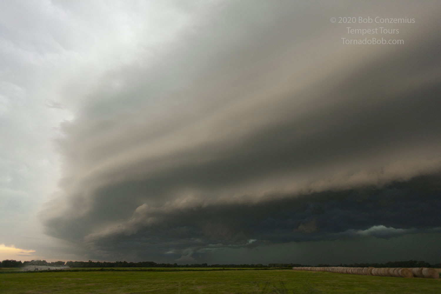
We got to the northernmost dryline storm and gave it what seemed like 20 minutes or so, but the base was not congealing like I would have hoped, and it seemed to be actually falling apart a bit while the cell to our east-northeast continued intensifying. It had a bit of a hook on radar. It was time to get underneath that storm. We broke off the dryline and headed east, and just as we were fully committed to that option, numerous small storms developed in-between the dryline storms and our target, and a line of storms would be the end result. That was not good for tornadoes. Oh, well. Time to play with shelf clouds.
There were one or two nice inflections in the line that we decided to chase, but upon reaching them, any mesocyclonic rotation would weaken, and the area would gust out. I decided to drop south and play passing freight train with individual cells, and we could get some nice shelf clouds that way. It was not a solid shelf cloud along the entire line, but there were segments with some nice structure. We stopped at took pictures of those.
It was at one of those stops (or maybe the drive in between them) where I noticed tornado warnings well to our west, along the dryline. Storms were zippering down the dryline, and the landspout threat had indeed materialized. There were a couple nice ones reported somewhere to the west or northwest of North Platte. If I had stuck with Plan A, we would have seen them, but it took unusually long for these landspouts to develop. Their timing seemed to be a couple hours behind average relative to the larger storm system's evolution.
Oh, well. We saw quite a few storms, and had a chance to do photography. It was a nice, active day. Not every event is perfect. As far as the tornadoes in Minnesota are concerned, just do a Google search for Ashby/Dalton tornado, and you'll see plenty of videos. It appears only Minnesota folks were there-- not too many chasers from out of state were up there. It looked like any other tour companies that were operating also probably chose Nebraska as the target. The tornado was Minnesota's first really strong/violent tornado in ten years (it was rated EF-4). The last EF-3 or greater tornado had happened July 17, 2010.
 |
|---|
| A shelf cloud over central Nebraska. |
 |
|---|
| This is the text that appears underneath the picture. |
Back to Storm Chases | Home