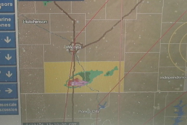
First storm 100 miles to our west.
This was the final chase day of Tour One of Tempest Tours. It was a very intense, strange, and hopeful yet frustrating day to say the least. We began in Wakeeney, KS thinking we might have a shot at any storms that developed in southeastern Kansas, which was really the only area we could reach for this moderate to high risk day. We began around 9:00 am after having arrived rather late to our hotel the previous evening. We drove southeast and exited I-135 just north of Wichita, then headed east and ended up in about the same area where we were on the first chase day of the tour around Independence, KS. I did not expect to see a storm, and in fact, I had somewhat put myself on "autopilot" for the day, just purposelessly driving south and letting Bill Reid do all the forecasting, but our initial half-cast target of southeastern Kansas actually looked very good when we arrived there, which was much better than I expected. I started to become interested in the chase.
After what seemed like about an hour of waiting along a dirt road, a lone storm initiated near I-35 in extreme southern Kansas. I thought the chase was on, but Bill did not start us west. Instead, we waited for a bit. On my own, it's possible I might have drifted after that first storm, but given the conditions that day and the progged fast storm motions, it was best to wait and let the situation evolve before running after a storm. This was a really good decision.
First storm 100 miles to our west.
Soon, a lot more storms developed around the first storm, and we quickly had a mess to our west, but we were in the fortunate situation of being well east of the storms and having time for them to evolve before they got to us. We started south in order to get to the "tail end Charlie" storm, but a line of storms started to develop to the south of our cluster. This caused some hesitation at first, but it was soon obvious that the only path to a photogenic storm was to continue south. The tail end storm would provide us with the best opportunity to see a tornado.
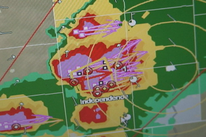
Soon, there is a large cluster of storms.
The southern propagation of the storm initiation finally ceased, and a tail end Charlie finally revealed itself. Actually, there were two storms that looked rather good and rather isolated from the rest. One was an easy catch southwest of us-- all we had to do was continue south. The other cell that looked good was just to the south of the first one. I was wondering whether we had enough time to get in front of that one, and I mentioned it over the radio. The only option was to keep driving south and to see what would happen.
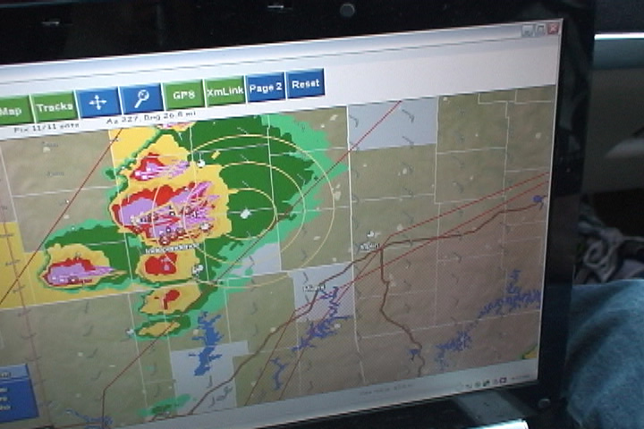
A line soon develops to the south. The southernmost cell, which only has "yellow" at this point, would go on to produce the Picher tornado.
As we drove south, I increasingly began to favor the southern storm of the pair rather than the northern one because the distance between the two was shrinking, and I thought the southern storm would provide our best chance of seeing something interesting. However, the northern storm was more mature, and soon the National Weather Service issued a tornado warning for it. This warning caused me a bit of uneasiness because I really did think the southern storm was better in the long term, but we were really getting close to our moment of opportunity, and with the rapid storm speed, we might have just one shot at viewing a tornado. We continued south to Columbus, Kansas. I heard a tornado report with the northern storm of the pair (which was now immediately west of us). I was still uneasy about this but not confident enough to insist on continuing south.
Bill took the west road out of Columbus and asked, "Want to go have a look at this one?" I reluctantly agreed since there was little time to talk about it. When I turned my van west, it was pretty clear things were not going the way I wanted. We were already getting a fair bit of rain, and there was very little cloud base visibility or contrast. There were also quite a few trees. We stopped about four or five miles west of Columbus (if I recall correctly-- maybe it was only a couple miles) to look at a somewhat disorganized base in the rain from the southern storm. I was frustrated. We really could not see anything. It was at this point that the tornado warning for the southern storm was issued, along with a confirmed tornado sighting.
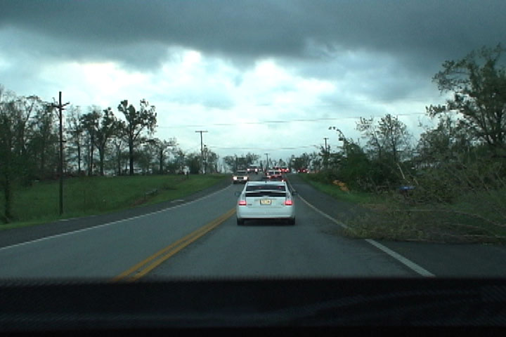
We turned around and hurried back east, but it was clear that we had already squandered our chances. I was pretty upset. Almost immediately, we were in heavy rain and a little small hail from the southern cell, and that would make it even more difficult to get east out of the precipitation and then south in front of the southern storm. We spent the next hour trying, but to no avail. The rain was just too heavy, the route too indirect, and the storm moving too fast, for us to make ANY progress. Do add insult to injury, around Sarcoxie, MO, pieces of house debris started to fall out of the sky around us. We were definitely on a storm that was producing a big tornado, but there was no way to see it. The first piece of debris that I noticed was a board that landed on the road immediately in front of me, with the nails pointed up! I steered around it to avoid getting a flat tire. Then, twigs, tin roofing material, and insulation started fluttering down around us. It was obvious that the tornado was shredding some houses pretty badly and that this was turning out to be a pretty tragic day for a number of people. I took some video while the debris was falling, but there was no way to see it on the video because of the heavy rain on the windshield.
We finally abandoned chase near Purdy, MO after crossing a wide, F1-type damage path. We came back around through Purdy and saw emergency vehicles assisting someone whose pickup had rolled through the ditch, over a fence, and into an adjacent field. That person may have ended up as a fatality. We saw other areas that had been hit pretty badly, including Neosho, on our way back to Tulsa for the evening. In total, this tornado killed 21 people. It had a path length of 75 miles and a width up to one mile. This is certainly the deadliest storm I have ever witnessed, but we did not quite see the devastation first hand.
In retrospect, we made every correct decision this day except for the decision to turn west instead of to continue south at Columbus. That was a very critical mistake. However, to continue south may have put us in a dangerous spot. By my estimate, we would have emerged from the core in Picher, OK and looked to the west to see a violent tornado approaching with no more than five minutes to spare before it hit the town. Perhaps we would have had less time than that and would have had to speed through town to escape. What I didn't know at the time was that in Columbus, Bill saw road closure signs ahead, which meant we did not have a direct route south, and this was a factor in his decision to turn west. Had we followed the detour south, I'm not sure we would have had enough time to emerge from the core and avoid driving into the tornado. Oh, well. The large number of fatalities left a rather sour note on this chase anyway, and out of respect for the people who suffered from this event, I'd have to say that it's best we did not get our tornado "enjoyment" from this event.
Damage path near Neosho, MO.