June 16, 2014
Stanton and Pilger, NE tornadoes.
I counted a total of six tornadoes from this chase. Depending on what one assumes as a threshold for tornadoes, I could have counted as few as four. One of these tornadoes hit the town of Pilger, NE really hard, resulting in two fatalities. Prayers, thoughts, and best wishes to the people who were affected. NWS Omaha has some documentation on these tornadoes here.
We started the day in Loup City, Nebraska and decided to head a little north, reaching Ord in time for lunch. We ate at a small cafe in the middle of town, then went back to the van to monitor radar for any development of storms. It wasn't long (maybe just a few minutes) until we saw the first echoes to our east. They didn't look strong and may have not been surface-based initially, but given the parameters where these new cells were developing, we decided the best choice was to stay with them in case they did become rooted in the boundary layer.
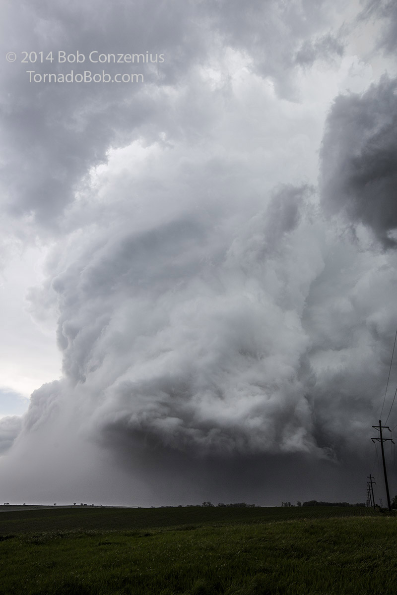
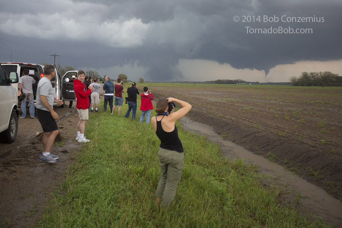
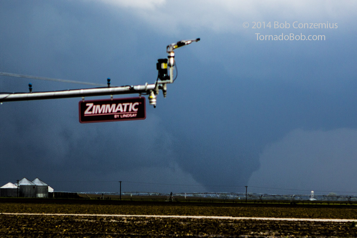
We drove east out of Ord and zig-zagged mostly east and a little north while the cells ahead of us slowly intensified. There was never any rapid intensification at any time over the next two hours, but with time, they gradually looked better. By the time we were nearing Madison, there were a number of rear flank downdraft (RFD) cuts into the back of the storm cluster. One RFD cut looked a bit larger, and we kept an eye on it. As I was driving, the tour guests identified a cone-shaped lowering extending most of the way to the ground, but we were too far away to see debris at the surface. By the time we were a few miles southwest of Stanton, the action area had become a very strongly rotating, large, bowl-shaped wall cloud. It was clear that the area would produce a tornado within five minutes.
Stanton Tornado.
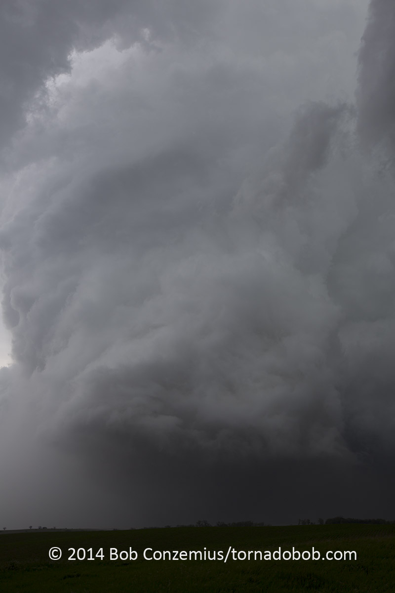
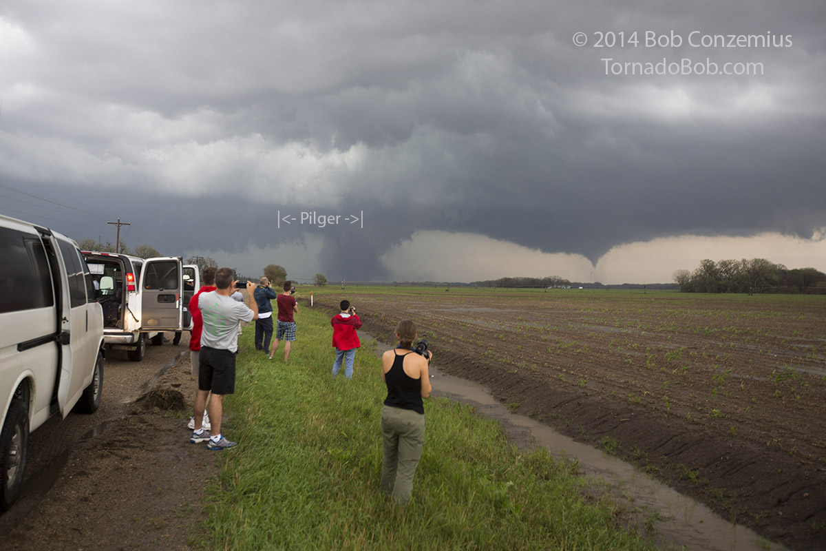
We took the turn north on Nebraska Highway 57 to Stanton, and I had a direct view of the rapidly rotating wall cloud, but there were small hills in the way to prevent me from verifying a tornado. We got closer and closer, but once we cleared one hill, the next one on the horizon was just as tall and equally effective at blocking our view. Finally, when we were just south of Stanton and started dropping into the Elkhorn River valley, the hills cleared enough to allow us to see a tornado, but it had become wrapped in a bit of rain. Just before we pulled into town, I got a glimpse of the multiple vortex structure with one vortex emerging on the right side. This was turning into a large wedge tornado! When we entered Stanton, I looked into the RFD cut directly ahead of me and saw a white, horizontal funnel develop on the updraft-downdraft interface on the east side of the tornado. I've generally seen those only on videos of violent (EF-4 or EF-5) tornadoes, and it was the first time that I've clearly seen one in person. I looked up further into the sky and could see the entire cumuloform cloud column rotating, all the way to the top. The entire updraft had axisymmetrized, and the tornado was occupying the whole updraft base! Perhaps it could have been more accurately stated that the updraft base was tightening and shrinking around the tornado as the occlusion process was beginning. Either way, the rotation from tornado up to the top of the visible cloud column was visually quite dramatic.
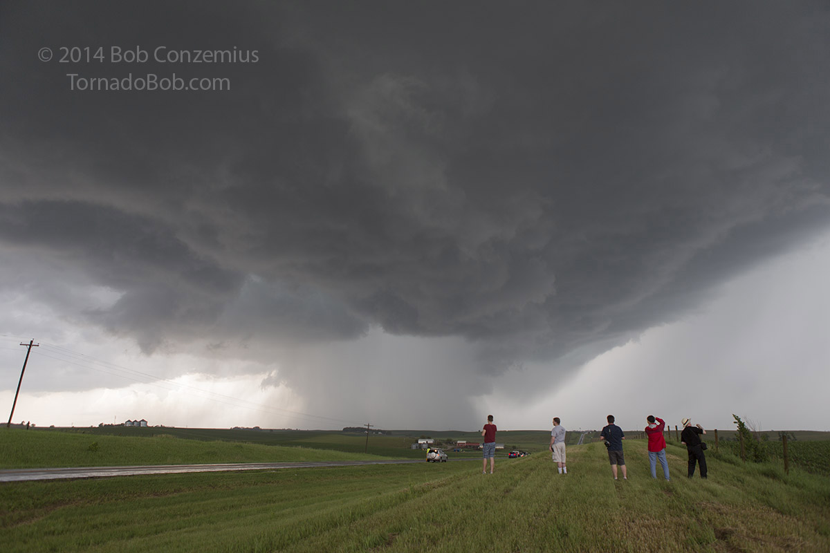
We drove through downtown Stanton and continued north on 57 to find a place to pull over and view. We were getting within a couple miles now, and it was time to stop, or else we would enter the damage path immediately behind the tornado as it crossed the road in front of us. We found a spot two miles north of town and 2.75 miles south of U.S. 275. We took pictures and video.
 |
|---|
| Stanton, NE tornado at 26 mm full frame focal length at 4:01 PM. Contrast is enhanced to help show the tornado, which is barely visible as the darker area beneath the cloud column. |
 |
|---|
| Stanton, NE tornado at 35 mm focal length without contrast enhancement. |
The updraft over the tornado was visually looking thinner now, and it was evident that the tornado was becoming occluded and would begin to rope out soon. I began the search for other areas of strong updraft and rotation at the cloud base. It didn't take long to locate one.
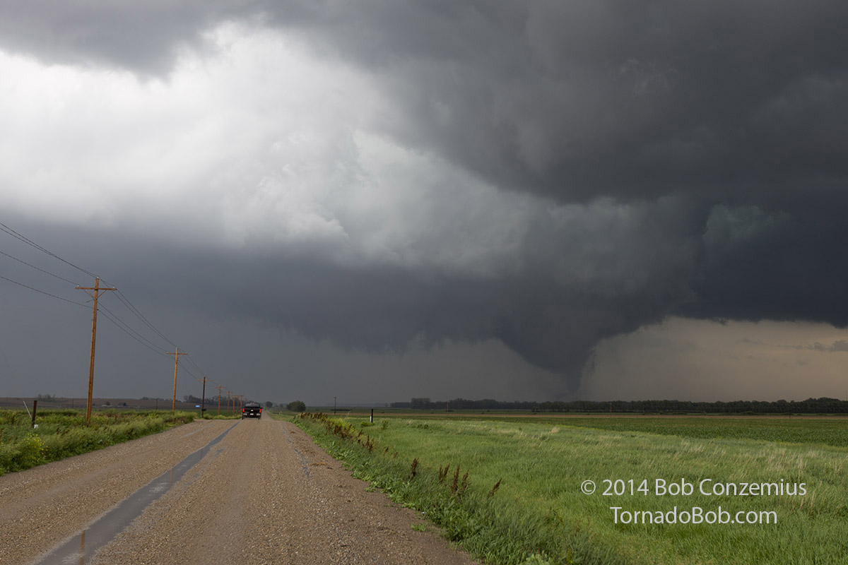
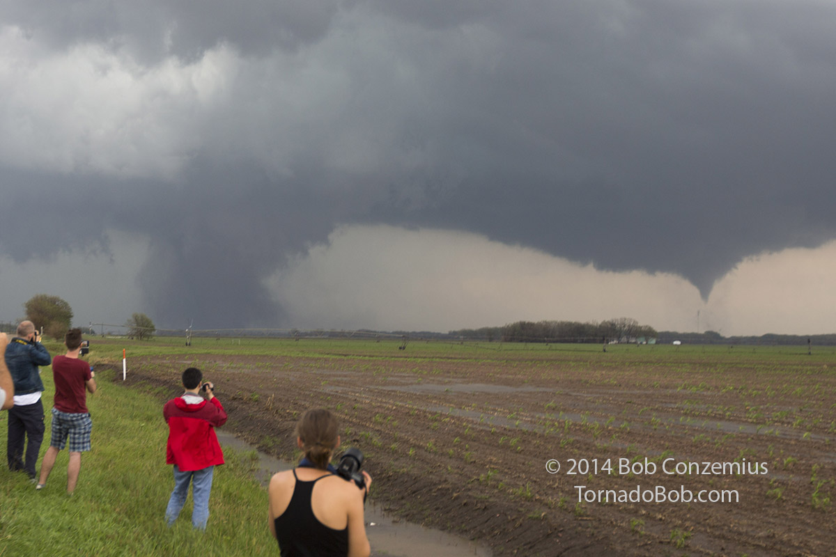
Pilger, Nebraska Twin Tornadoes
Immediately, I saw rapid rotation to the east. I yelled out to alert people of the new, rapidly rotating wall cloud, and soon everyone was back in the vans. Rather than continue north on 57 where we risked the road being blocked by downed trees and power lines, we dropped back south to find an east option out of Stanton. Less than a mile down the road, the first debris whirl appeared, and the first of the Pilger, NE twin tornadoes was born. We took a small road east-northeast from Stanton. which headed directly for the tornado. We elected to stop and let the guests take pictures and video when we were seven miles west-southwest of Pilger. We stayed for a minute or two, during which time the Stanton tornado reemerged from the rain as a rope tornado to our north. However, the new tornado was moving away quickly, so we needed to get moving again to stay up with it.
 |
|---|
| Pilger, NE tornado at 4:10 PM. 35mm, cropped. |
 |
|---|
| Closer, cropped view. |
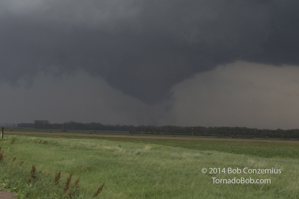
We got back in the vans and drove east again, but we only went another mile because a third tornado quickly developed to the right of the second tornado. As soon as we saw this rare event begin to unfold, we stopped at a location six miles west-southwest of Pilger. From that location, we watched as the tornado probably began to enter Pilger, although it was not perfectly clear to us at the time. I had no discrete pieces of debris in any of my stills or video, and by looking through other videos of this event, it is clear the pieces would have been large enough to be visible in my video and stills. From what I have been able to determine (by close examination of other chasers' videos, time stamps on my camera, and plotting our locations and lines of sight relative to various landmarks on Google Earth), the tornado hit the town just as we were beginning to drive away from this second location. Had I been looking more closely, I probably would have noticed the large pieces of debris being lofted, but by the time that happened, I was probably too busy driving and looking around at the storm for additional areas of rotation, or perhaps, our line of sight was blocked at that time. My next picture was taken at 4:24 PM, about six minutes after the town had been hit.
 |
|---|
| Twin tornadoes with the second of the twins just developing to the south of the first one at 4:16 PM. |
 |
|---|
| 4:17 PM. As far as I can determine by NWS damage survey, other videos, and plotting our locations and landmarks on Google Earth, the tornado on the left was probably entering the town of Pilger as this picture was taken. The approximate horizontal extents of the town are indicated. |
 |
|---|
| Cropped version of the same image above. |
We picked up and drove again, with me not realizing that Pilger was taking a direct hit. The third and final stop was 4 miles west-southwest of Pilger. We had wanted to continue, but our dirt road was blocked by running water, so we would have to turn around and go north to U.S. 275 as soon as we were done filming here. By the time we got out and I snapped pictures again at about 4:24 PM, one of the tornadoes had already disappeared. I seem to recall it was the first twin that disappeared because I identified the remaining tornado at the time as the second of the twins.
 |
|---|
| 4:24 PM. The second tornado with the first one (the one that hit Pilger) having disappeared into the rain. The water tower of Pilger is to the right of the still visible second tornado of the twins. The tornado that hit Pilger is probably just off the left side of the picture and has temporarily weakened a bit. |
 |
|---|
| 4:24 PM. Higher contrast picture taken at the same location as above. |
We packed up, drove north to U.S. 275 and headed east, where we came across a couple damage paths. For some reason, I was not paying much attention as we passed Pilger, but I did notice a scoured corn field from the second of the twin tornadoes. The corn plants had been completely removed from the tornado path, and all that was left was scoured black dirt. The path crossed 275 into a feed lot, where there were heavily damaged silos, and apparently, a lot of dead cattle. I was driving and did not actually see them. Black angus cattle are not easy to distinguish from black dirt.
At this point, Bill thought we may be too far behind to catch up because we could not longer see any structure, and the storm was moving rather quickly northeast. However, we kept on driving and soon realized we were not as far behind as we thought. As we crested the next hill on Highway 51, a very large truncated cone tornado appeared with a satellite tornado rotating around it. I was not sure if this was a continuation of the twin tornadoes or if it was a new one, but it turns out these two were new tornadoes (#4 and #5). The satellite tornado appeared to become absorbed, or else it simply rotated behind the larger tornado and dissipated, but in either case, we ended up seeing one large, fully condensed fat cone/wedge that, with time, became wrapped in rain and disappeared, maybe around the time we passed through Pender. By the time we were approaching Emerson, it was clear that there was no tornado remaining in the rain, but it also may have moved to the north and beyond the rain area that we were looking at. One of the guests found a near-baseball-sized hailstone at this location.
 |
|---|
| Rain area a few miles south of Emerson, NE at 5:16 PM. |
From there, took a quick pit stop in Emerson before continuing to chase the storm. As we exited town, the storm put together two more areas of intense rotation, but it was apparent the storm was shrinking. One of the areas of rotation produced a weak, brief, ragged tornado whose ground contact we could see about half a mile to our north at the edge of a field, but as soon as we stopped and I got my camera out, it had dissipated (tornado #6 for the day).
From there, we continued into Sioux City, where the storm dissipated entirely. There were more storms from near Sioux Falls eastward into Minnesota, and we targeted the westernmost storm, but everything was undercut with relatively cold air and east-northeast winds. We then targeted some cells moving northeastward out of central Nebraska, but they were rather multicellular by the time they got to us and were merging into one very heavy rain event over the Siouxland region. I-29 became impassible due to flooding. We stayed in Vermillion, SD for the night.
Back to Storm Chases | Home