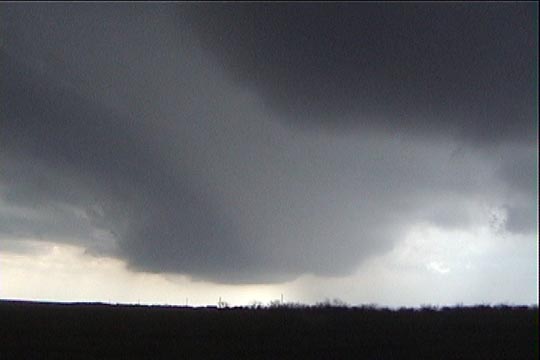
West of Throckmorton, TX. Storm has a nice, bowl-shaped updraft.
This must be one of the most painful chases I've ever experienced and ranks as the most significant chase mistake I've made in my chase "career" to date. This is basically the same mistake I made at Brady, NE on May 17, 2000, so what's particularly hard to take is the fact that I made the same mistake AGAIN!! What started out (and also ended) as a perfect forecast scenerio that verified to a "T", ended up for us as a lost opportunity to take stills and video of a tornado that simply cannot be beat for high-contrast, good view, and intensity, as well as the fact that it harmed absolutely nobody.
RJ Evans, Gene Rhoden, and I headed south towards Abilene, TX to the location of an east-west outflow boundary that was set up in that area. An upper low was in west Texas, and winds around the upper low were pretty strong, but the shear was mostly unidirectional in nature, so, in general, the expectations for rotating storms were not that high. However, during the morning, it soon became evident that a window of opportunity was available for rotating storms, as outflow from ongoing, elevated convection in Oklahoma had set up a boundary in north Texas. Additionally, some clearing occurring around the outflow boundary itself was allowing rapid destabilization to occur just to the north of the boundary, where the surface winds were still easterly. Thus, the ingredients were there, over a limited area, for some significant storms. The main concern was that the progged, northward-moving storms would not have a long time to ingest high-CAPE air north of the boundary before they entered a region of cooler surface air and became elevated.
We drove southwest to Seymour, TX, where we ran into Chuck Doswell and Hank Baker. After talking to Dan Miller (who made a great forecast) on the phone, we became aware of some new cells that were developing to the southwest of us near Haskell. We immediately drove in that direction to intercept these storms. We decided to intercept the eastern storm of the pair that we saw. A core punch with some 1.5" hail was necessary in order to get under the updraft base, which had a nice bowl shape to it.
West of Throckmorton, TX. Storm has a nice, bowl-shaped updraft.
Upon reaching the base to the east of the core, it was apparent that our winds were westerly (i.e. not inflow). This convinced us to proceed eastward with the idea that we could catch newer cells as they came up from the southeast ahead of our current cell. Additionally, as we proceeded east, the storms behind us, for a while, looked increasingly linear in appearance, so we continued to run away from them as if they carried bubonic plague.
Soon, the updraft base to the west-southwest began showing undulations and lowered quite a bit, but this was not enough to get us to turn around and head back west. The flag we saw in Throckmorton point straight west into this area was not enough either. Thanks to RJ's newly installed RM Young temperature and dewpoint sensors, we were able to get a good idea of what the surface theta-e was. As we dropped south of Throckmorton (in search of new cells), the dewpoint climbed to 67 before leveling off and slowly dropping as we continued southward toward Breckenridge. There, the dewpoint dropped more suddenly into the lower 60's, and the wind suddenly veered to a 170 direction. This convinced us that we were no longer north of the boundary. Visually, all the low-level cloudiness and haze was also gone, telling us that the low-level theta-e air we were in earlier was not with us anymore. Time to turn around and book back north!!! By the time, we got back there, the Throckmorton tornado was long gone.
See Chuck Doswell's page for some excellent images of this tornado.
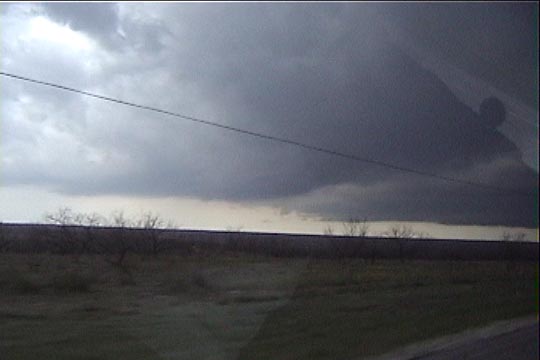
Throckmorton, TX storm about 20 minutes before the tornado. Note the base of the storm
on the right side of the picture.
There was one positive result of this event, and it was pretty significant. Gene, RJ, and I got a very good mental image of the low-level theta-e field in the vicinity of the boundary. We saw the dewpoint gradually creep into the lower to middle 60's as we drove south from Seymour while we were still in easterly winds. Dewpoint was 65 just east of the storm (temp was in the mid-upper 70's). Just southeast of the storm, dewpoint peaked at 67.5 (with winds from 110). Then the dewpoint slowly dropped, and the winds gradually veered to 130 or 140 as we drove southward, finally dropping quickly into the low-60's and veering suddenly to a 170 direction just to the north of Breckenridge. It was apparent to us that the tornadic storm was feeding on air that 1) had maximum CAPE and 2) maximum low-level helicity. Next time, I hope to be more patient around pre-tornadic storms. Hopefully, Brady and Throckmorton are the only times I'll make this mistake.