The Setup
Return moisture from the Gulf and a dryline provided an opportunity for discrete supercells over western Oklahoma. The moisture was not the highest quality (dewpoints reached into the 60s, not the 70s), so the tornado risk appeared to be low. Nonetheless, wind profiles looked good for supercell storms. The Storm Prediction Center issued a slight risk for severe storms across most of western Oklahoma.
The Chase
We began the day in Wichita Falls and made our way through western North Texas. Since we had plenty of time, we decided to take a tourist route and cross what was formerly known as the Bridge of Doom (that's the way I remember it). This old bridge across the Red River has since been replaced, but it remains a fun crossing between Texas and Oklahoma because the area is rather remote.
We stopped and offered tour guests the opportunity to walk across the bridge or go down into the river bed and walk across that. For reference, the river was pretty low. There was only one small channel with any water, and if you crossed it on foot, the water wouldn't get much past your ankles. However, you did have to be aware of the danger of sinking into the muck in some parts of the riverbed. It was sort of a quicksand, and if you begin to sink, it can be easy to work your way deeper and difficult to get out. I drove a van across the bridge to Oklahoma, then got out and walked around (carefully) on the river bed. I waded across the river and back.
While we were having fun here, towering cumulus were growing. Eventually, we decided it was best to go into chase mode. We drove through Hollis, did a pit stop there, and proceeded westward into Texas to target some of the developing storms. These storms struggled quite a bit, and none of them appeared destined to organize into supercells. All the bases were high, and the mode was multicellular.
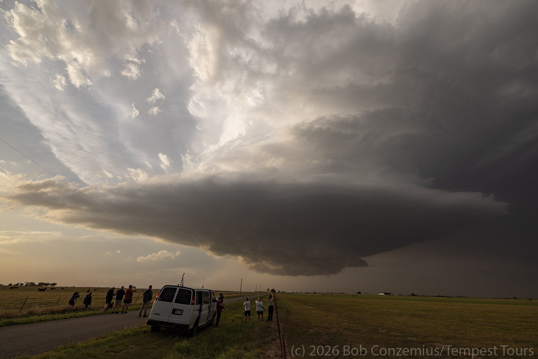
Thus, we drove north at some newer echoes a little north of I-40 near Wheeler, TX. These showed more potential with taller echo tops and a more discrete look. We arrived east of this storm in Oklahoma north of Erick. We pulled up and watched this high-based supercell approach us over the better part of an hour.


When the base came much closer to us, we redeployed a few miles farther south. At this second location, we were treated to some nice light effects with an isolated shaft of sunlight shining between two storms, illuminating the hazy skies to our east. This is one of the brightest such shafts of sunlight I've seen on a chase. Otherwise, our storm developed a more circular base, but it appeared to be shrinking slightly. I was concerned that our show might be coming to an end a bit early.


Restrengthening
My fears were unfounded. The storm, once again, grew in strength. We dropped south and did a quick pit stop in Erick then drifted a little south of I-40 for another look at the storm. It was warned and had some pretty large hail. One of our guests was watching a live stream of other chasers in the highest reflectivity portion of the storm losing windshields from hail.
We pulled over on a more remote road and watched for another 30 minutes as our storm developed a wall cloud and an awe-inspiring spaceship appearance. It was nice to have a slowly moving, photogenic storm. We took a few pictures but mostly took in the scene since there was plenty of time.


Awe-Inspiring Sunset
The storm continued on its path east-southeastward. This was clearly not a tornado day. It was a structure day. Given the sun angle, it was now time to let the storm get a bit east of us and enjoy the illumination from the sunset. This was a wonderful scene as vivid colors and spectacular cloud formations spread over the entire sky. I took a bunch of pictures, but it seems like they fail to convey how this moment felt. Maybe I should look at them on a larger monitor or try to adjust levels in Camera Raw some more. Whatever the case, I'll just put them here for you to look at.


Wrap-up
This might have been my favorite day of Tour 3A. There were no tornadoes (and everyone, of course, wants to see tornadoes), but we had a high quality chase featuring a slow-moving, highly visible, well-structured supercell storm. We stayed out of heavy precipitation so there was no threat of hail damage to the vans. The experience either side of sunset was surreal and transformative. We were awash in so many colors and reflections of light. The storm was awesome to behold, and we could relax and take it all in.